
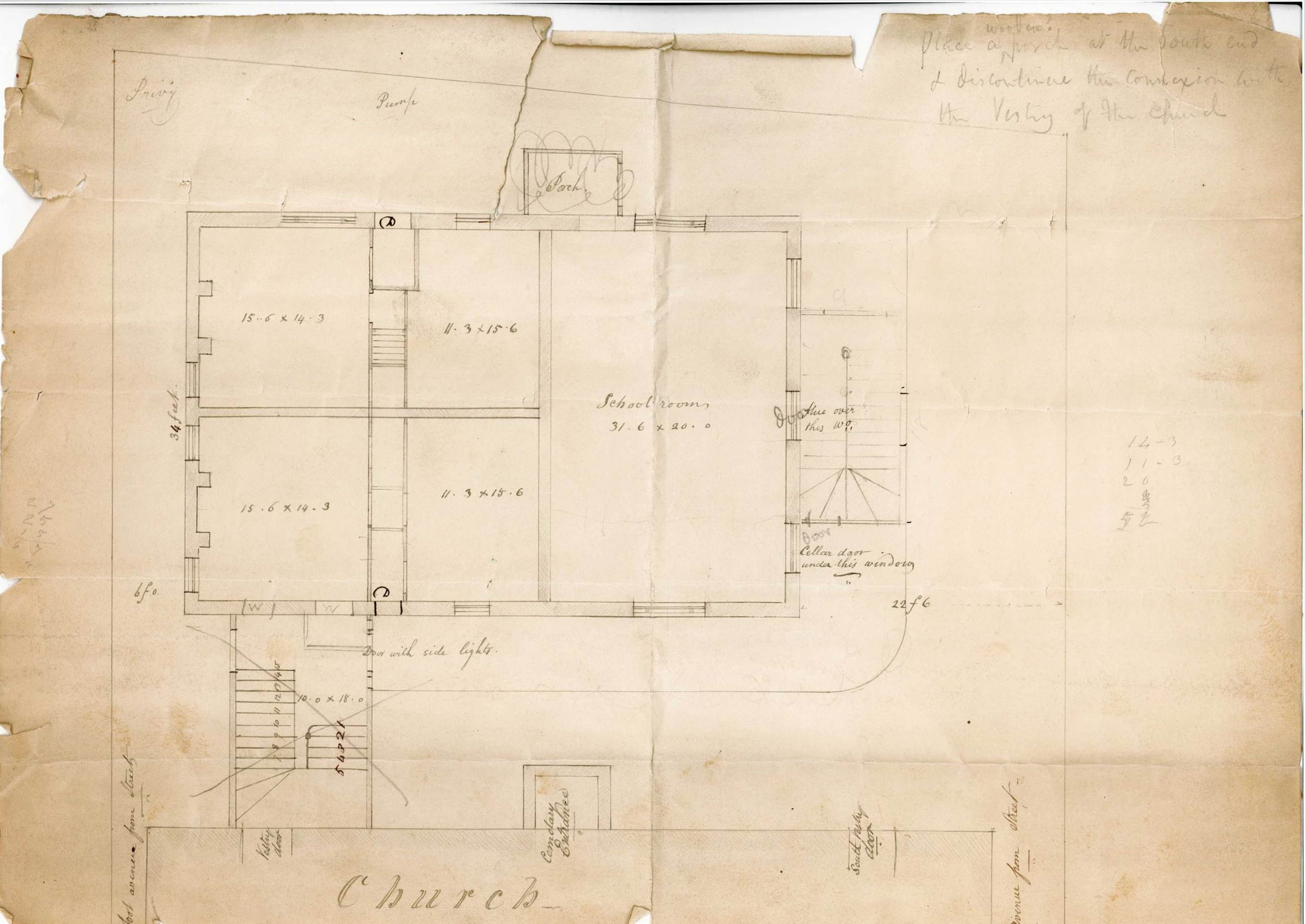
St. Paul's Sunday School Building
In October of 1839 this first school building associated with St. Paul’s Church open for use by the parish. The building was constructed for both a Sunday school, apartments, and other purposes of the parish.
Originally published on October 15, 2020.
In October of 1839 this first school building associated with St. Paul’s Church open for use by the parish. The building was constructed for both a Sunday school, apartments, and other purposes of the parish. The building was built of brick with a slate roof, and copper gutters to conduct water to the cistern. In the contact it is specified that “all the building walls to be lathed & plastered, with stucco cornices in the hall, handsome & of suitable size”. The building was to also provide for two tenement apartments of four rooms with suitable closets. The contract further specified that the wood work to be painted – three coats. The cost of the construction was contracted at $5,400. The contract was signed by James Savage and Henry Codman.
Of note in the scanned images titled St. Paul's Church Boston - Sunday School Building you will see in pencil (top left) the location of the privy in the north-east corner of the property.
Photos saved on Flickr.com.

The Neighborhood
When St Paul's opened in 1820, Tremont Street was still a residential neighborhood. The neighborhood soon changes when the Back Bay neighborhood is developed with new luxury townhouses starting in 1859.
Originally published on July 23, 2020.
When St Paul's opened in 1820, Tremont Street was still a residential neighborhood. The neighborhood soon changes when the Back Bay neighborhood is developed with new luxury townhouses starting in 1859. The two photos to the left show remnants of the residential home that were once part of Tremont Street. By the late 1860's Tremont Street will become more of a place of commerce and less residential.
Photos saved on Flickr.com.


Selecting the Site of St. Paul's
In this four page document we see the founders’ thought process as they selected a site for St Paul’s in the growing town of Boston.
Originally published July 9, 2020.
In this four page document we see the founders’ thought process as they selected a site for St Paul’s in the growing town of Boston. To give you an idea of what Boston was like in 1819 take a look at the map from 1814. The corridor of what is now Washington St (noted by the orange line on the map.) This road would have led a resident to the extreme end of the town, and it was often referred to as Boston Neck. This narrow “neck” would have then led to the town of Roxbury. In between those two towns was a wetland, now the neighborhoods of the Bay Village, the Back Bay, and The Fenway. These neighborhoods do not yet exist in 1819. The Committee decided to buy a few lots across from the Common that already have buildings and “clear the site of its encumbrances” in order to construct St Paul’s Church. The location of Old North, Trinity Church, and King's Chapel have been marked to give you an idea of how these churches were spaced apart from each other.
Sources from the Cathedral archives.